
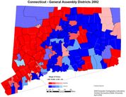
This map shows us a few things that we already knew. One: Republicans are dominant in Fairfield and Litchfield Counties. Two: Democrats have a lock on the cities and inner burbs. Three: Most of these districts are "safe". Only a few of them are ever in play. Of 151 districts, only 31 were won with less than 20% of the vote. Many were not contested by one of the major parties. I do understand why Democrats might not want to run in Greenwich, but why a district that included Middlebury and Waterbury? Or in Groton? Maybe these aren't guaranteed wins, but they would be pretty close. The Republicans, if anything, are worse. District 8, Columbia, Coventry and Vernon, is winnable for a Republican. District 57, Ellington and East Windsor, practically begs for a Republican to run in it. Nope.
Ours is a system that favors those who play it safe, and has been engineered that way by both parties. This map illustrates that clearly. So few of these races are close (really, only one or two races were ever in doubt) that it's amazing that we have the turnover that we do. I don't expect this trend to change anytime soon.
One interesting thing is that this map is the closest to the town council control map. This, too, is not surprising. The state reps. are only one level up from the town councils, and voters' preferences for state representatives are very close to tehir preferences for town councils. We find Republicans and Democrats where we expect to find them on both maps; very few surprises here. See the maps side by side (state reps on the left, town councils on the right):
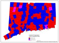
Neat, huh? It appears that the state reps map will be most useful in predicting the outcome of municipal elections. We'll see how accurate it is in May and November.
2 comments:
I really enjoy the maps. Thank you. I have past along your blog to some of my friends at the CT legislature.
That's maps are great...they look really good. I went to high school in Sen district 60 -- Litchfield County. It sucks to see it's pretty solid GOP.
How did you make these maps? I'm very active in Virginia politics and would love to do the same.
Post a Comment